Place de la Concorde
The largest square in Paris, with an Egyptian obelisk at its centre
- Area 1st arrondissement
- Type Landmark
- Time needed 30m
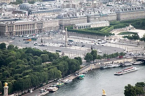
Place de la Concorde is the largest public square in Paris, laid out in the 1750s and renamed after the Revolution, during which the guillotine stood here and Louis XVI was executed in 1793. At its centre is a 3,300-year-old Egyptian obelisk from the temple at Luxor, given to France in the 1830s. It sits at the bottom of the Champs-Élysées and the western end of the Tuileries, so most visitors cross it rather than visit it. There is nothing to go inside.
Open in the planner →Getting there
Concorde station is served by Métro lines 1, 8 and 12 and comes up directly onto the square; from Châtelet it is about 7 minutes on line 1 with no change. Tuileries on line 1 is one stop east if you would rather walk in through the garden. Several bus routes along the rue Royale and the quai stop at the square, and the Batobus river stop at the Champs-Élysées landing is a few minutes down the quai. There is no far-end walk to speak of: you step out of the Métro into the middle of it.
What you see
The obelisk is the fixed point, with its gilded pyramidion and hieroglyphs on all four faces, and a plaque at the base explaining how it was shipped and raised. Two large bronze fountains flank it, one themed on rivers and one on the sea, both heavily restored and worth a slow circuit for the tritons and nereids. Around the edge stand eight stone figures representing French cities, each on its own pavilion corner. Then look along the axes, which are the real reason to stand here: west up the Champs-Élysées to the Arc de Triomphe, east through the Tuileries to the Louvre, north up the rue Royale to the columned front of the Madeleine, and south across the Pont de la Concorde to the Assemblée Nationale. The Hôtel de la Marine and its twin on the north side are the original eighteenth-century buildings that frame the whole thing.
What to pair it with
The Tuileries Garden begins at the square's eastern edge, and the Musée de l'Orangerie stands just inside it. The Champs-Élysées runs west from the other side. Pont Alexandre III is about ten minutes along the Seine to the south-west.
When to go
Early morning is much the best time, because the square is a working roundabout and the traffic noise is constant from mid-morning until late evening. Sunset, when the light runs west up the avenue, gives you the Arc de Triomphe lit at the end of it, which is the photograph people come for. It is busiest in the afternoon and on summer evenings. Winter brings the Christmas market lights along the lower Champs-Élysées in some years, which changes the view east to west.
What is hard about it
There is nothing to enter and no reason to linger long: it is a vast traffic island with fast-moving cars on every side, and crossing to the obelisk means waiting at several sets of lights. The scale that looks grand in photographs reads as empty and windswept on the ground, and there is very little shade or seating. Pedestrian layouts here have been altered repeatedly and parts are often fenced for works or events, so a crossing that was open last year may not be. People who allow an hour usually find twenty minutes is plenty.
Common questions
How long do you need at Place de la Concorde?
Twenty to thirty minutes covers the obelisk, the fountains and the views along all four axes. It is a crossing point rather than a destination.
Is there anything to go inside?
Not on the square itself. The Hôtel de la Marine on the north side can be visited separately with a ticket, and the Orangerie is a short walk into the Tuileries.
Is it worth visiting at night?
Yes, for the lit obelisk and the view up the Champs-Élysées to the Arc de Triomphe. The square is open ground with normal street lighting and traffic, so it is no quieter than by day.
Nearby
- LouvreThe largest art museum on earth, in a palace, behind a glass pyramid
- Tuileries GardenThe formal garden between the Louvre and the Concorde
- Palais-RoyalArcaded gardens behind the Louvre, with Buren's striped columns
More of the same kind
- Eiffel TowerGustave Eiffel's 330-metre iron tower, the one unmistakable thing on the skyline
- Arc de TriompheNapoleon's arch at the top of the Champs-Élysées, with a roof terrace
- Palais GarnierGarnier's opera house, all marble staircase, gold and Chagall ceiling
- Les InvalidesThe gilded dome over Napoleon's tomb, and the army museum beneath
Part of these routes
- The grand axisGarnier's opera house, the great avenue and the two palaces of the 1900 fair.
- Paris in three daysThe short list, ordered so each day holds together and nothing is crossed twice.
- Paris in five daysA fuller first visit: the island, the Louvre, the Left Bank, Montmartre and Versailles.
- Paris at lengthEverything the other routes cover, spread over unhurried days with nothing rushed.