Canal Saint-Martin
Iron footbridges, plane trees and nine locks through the 10th
- Area 10th arrondissement
- Type Neighbourhood
- Time needed 1h 15m
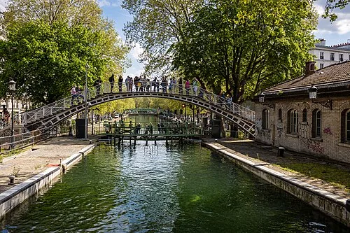
The Canal Saint-Martin runs for about 4.5 km from the Bassin de la Villette down to the Seine at the Port de l'Arsenal, dropping some 25 metres through nine locks. It was ordered by Napoleon and opened in 1825 to bring fresh water and freight into the city; the southern stretch below République was vaulted over in the 19th century and now runs underground beneath boulevard Richard-Lenoir. The open section through the 10th, with its iron footbridges and double rows of plane trees, is a walk rather than an attraction, and costs nothing.
Open in the planner →Getting there
For the open stretch, Metro 5 to Jacques Bonsergent or Metro 5 and 2 to Jaurès put you on the water in a few minutes; Metro 3, 5, 8, 9 and 11 to République is a five-minute walk and about eight minutes from Châtelet on line 11. The southern underground end surfaces at the Port de l'Arsenal by Bastille, on Metro 1, 5 and 8. Buses 46 and 75 run along it. The honest advice is to arrive at one end, walk the towpath, and leave from the Metro at the other: Jaurès to République takes about forty minutes at a slow pace.
What you see
Walk the quai de Valmy or the quai de Jemmapes and you pass a sequence of locks where boats are raised and lowered in full view, which is the main thing to watch; the double locks near the Hôtel du Nord are the most photographed. Cast-iron footbridges arc over the water between the plane trees, and two of them are swing bridges that rotate out of the way when a barge comes through. The water is green and still between locks, and the brick and stone quais are lined with bars, bookshops, independent clothing shops and a lot of people sitting on the edge with bottles and takeaway food. South of République the canal disappears under the road at a long vaulted tunnel mouth. North, the Bassin de la Villette opens out into a wide basin with a cinema and rowing boats.
What to pair it with
Place de la République sits at the midpoint, the Parc des Buttes Chaumont is about twenty minutes' walk north-east from the upper end, and Place de la Bastille is at the southern, buried end.
When to go
Sunday afternoons and summer evenings are when Parisians sit along the water in numbers, and both banks of the quai de Valmy are closed to traffic on Sundays and public holidays, which makes the walk much better. If you want the canal quiet, come on a weekday morning. Autumn, when the plane trees turn, is the best-looking season. Winter weekday afternoons can feel bleak.
What is hard about it
There is no monument here, no ticket and nothing to go into: if you do not enjoy walking and looking at ordinary city life, there is nothing to see. The canal is not clean, and litter along the banks after a busy evening is common. Traffic runs beside long stretches on weekdays and the noise carries. The southern half is underground, so do not plan a continuous walk from Bastille. Occasional draining of the canal for maintenance leaves it empty and unattractive for weeks. The boat trips through the locks and the tunnel take over two hours and need booking.
Common questions
How long do you need at the Canal Saint-Martin?
Allow an hour and a quarter to walk the open section between Jaurès and République with stops at the locks.
Do you need a ticket?
No. It is an open public towpath with no charge. Only the canal boat trips are ticketed.
Can you walk the whole canal?
Not continuously. The stretch south of République runs in a tunnel under boulevard Richard-Lenoir, so you walk above it rather than beside it.
More of the same kind
- Champs-ÉlyséesThe two-kilometre avenue from the Concorde to the Arc de Triomphe
- MontmartreThe hill village the city grew around, steep, cobbled and crowded
- Place du TertreThe small square behind Sacré-Cœur, full of portrait painters
- Île Saint-LouisA single seventeenth-century street on an island, almost unchanged