Parc des Buttes Chaumont
Cliffs, a lake and a temple on a crag, built on an old quarry
- Area 19th arrondissement
- Type Park
- Time needed 1h 15m
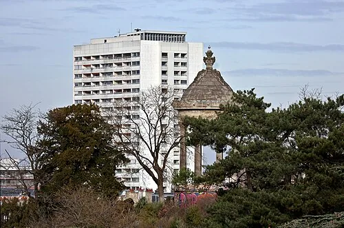
The Parc des Buttes-Chaumont covers about 25 hectares on the side of a hill in the 19th, on the site of a gypsum quarry and refuse tip. Haussmann and the engineer Alphand built it for the 1867 exposition, blasting and shaping the ground into cliffs, a lake and a crag with a temple on top. It is one of the hilliest parks in Paris and the ground inside it falls nearly 30 metres.
Open in the planner →Getting there
Metro 7bis to Buttes-Chaumont or Botzaris puts you at a gate; from Châtelet take line 11 to Place des Fêtes or line 7 then 7bis at Louis Blanc, about twenty minutes either way. Metro 11 to Pyrénées or Jourdain is a five-minute walk to the eastern gates. Buses 48, 60 and 75 pass the edges. Which gate you use matters: Botzaris and Laumiere are gentler, while the Place Armand-Carrel entrance puts you at the bottom of the steepest climb.
What you see
The centre of the park is a lake wrapped round a rock island, with a cliff face left from the quarry rising sheer out of the water. On top of the crag is the Temple de la Sibylle, a small round colonnade modelled on the temple at Tivoli, reached by two bridges: a brick-arched one and a suspension footbridge slung high across the gap, designed in Gustave Eiffel's workshop. From the temple there is a view north-west over the rooftops to Montmartre and Sacré-Cœur, which is the best thing in the park. A waterfall drops into an artificial grotto with hanging stalactites below the cliff, and paths wind down through it. The rest is steep lawns where people sit on the slope, a bandstand, two café pavilions and long sinuous walks under mature trees.
What to pair it with
The Canal Saint-Martin is about twenty minutes' walk south-west, and the Bassin de la Villette and Parc de la Villette are a similar distance north. Belleville and its own hilltop views are fifteen minutes south.
When to go
Weekday mornings are quiet. Sunday afternoons in good weather fill every slope with people and the cafés have waits. Late afternoon gives the best light from the temple towards Montmartre, and autumn is the strongest season for the trees. The park closes at night and the hours move with the season. After heavy rain the unsealed slope paths get slippery.
What is hard about it
It is steep, and that is not a detail: reaching the temple means a real climb and several flights of steps, with no level route to the top. The suspension bridge is sometimes closed, which forces a long way round. The grotto and waterfall are drier and less impressive than photographs suggest, and the lake is more ornamental than scenic up close. There are only two cafés for a large park and they are busy at weekends. It is a twenty-minute Metro ride from the centre on a short branch line, which is a lot of travel for a park if your time in Paris is limited.
Common questions
How long do you need at Buttes-Chaumont?
An hour and a quarter to walk the lake, climb to the temple and come back down through the grotto. Longer if you sit on the grass.
Is it worth the trip out?
Yes if you like parks and want a view towards Sacré-Cœur without the Montmartre crowds. No if you are in Paris for three days and have not seen the centre.
Is it accessible without stairs?
Not to the temple. The lower circuit round the lake and the main carriage drives are manageable, but the crag is stairs only.
More of the same kind
- Jardin du LuxembourgFormal gardens round the Senate, with green chairs and a toy-boat pond
- Tuileries GardenThe formal garden between the Louvre and the Concorde
- Parc de la VilletteThe largest park in Paris, scattered with bright red follies
- Bois de BoulogneThe city's western wood, with lakes, gardens and racecourses